
Farmers Branch ZIP Code Coverage
Census profile results identify seven ZCTAs that intersect the Farmers Branch place: 75001, 75006, 75229, 75234, 75240, 75244, and 75254. This is an intersection list, not a claim that every address in a listed ZIP is inside the city or has Farmers Branch as its USPS mailing city. The 75381 code appears separately in a dated USPS local-delivery pilot, but its regular residential geography and unique-status were not confirmed in the research.
| ZIP Code | Areas Covered | Post Office | Notes |
|---|---|---|---|
| 75001 | Addison and nearby northern or eastern interface | Nearby Addison service | ZCTA intersection only; verify each delivery address |
| 75006 | Carrollton and southern or western interface | Nearby Carrollton service | Postal city and municipal city can differ |
| 75229 | North Dallas interface | Northaven Dallas nearby office | Intersection does not establish a Farmers Branch label |
| 75234 | Core Farmers Branch postal context | Farmers Branch Post Office | Post-office source is the delivery authority |
| 75240 | North Dallas and Richardson-adjacent interface | Nearby service context | ZCTA and place overlap only |
| 75244 | Farmers Branch and Dallas interface | Farmers Branch Post Office service context | ZIP can extend beyond city limits |
| 75254 | North Dallas and Addison interface | Nearby service context | Not a complete postal-city list |
| 75381 | USPS local-delivery pilot context | Farmers Branch Post Office service list | Do not assume ordinary residential use |
The Census explanation of ZCTAs is important here. A ZCTA is a generalized Census geography built from blocks, while a ZIP code is USPS route geography. It can be noncontiguous, include a PO box or institution, or cross a city boundary. That is why this ZIP code directory keeps the coverage labels cautious.
Farmers Branch ZIP Code Post Office
The official USPS Farmers Branch Post Office listing places the office at 13904 Josey Lane, Dallas, TX 75234-9998. Its mailing-city label is a useful local reminder that a post-office address and a municipal name need not match. The listing gives retail service Monday through Friday from 8:30 to 5 and Saturday from 8:30 to noon, along with PO-box service and a 972-620-9132 telephone number.
The USPS local-delivery pilot announcement dated 2021 listed 75234, 75244, and 75381 as service ZIPs for this post office. That dated list describes a pilot service context, not a current boundary map. Use the official address lookup for a live delivery question.
The USPS office result provides the address, service, and nearby-office context for this Farmers Branch ZIP code directory.
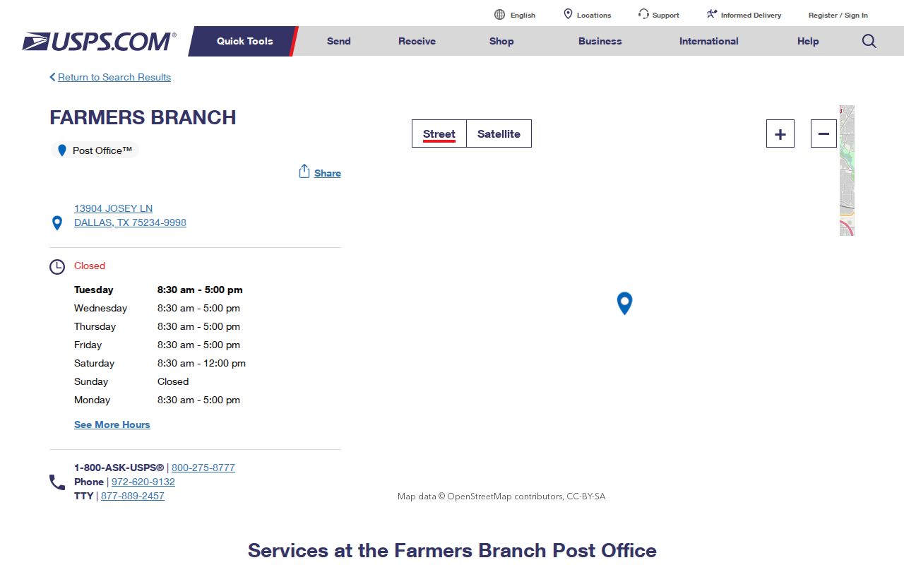
It also lists nearby Carrollton, Valley Ranch Irving, Addison, and Northaven Dallas offices, which helps explain why a nearby ZIP label is not proof of city jurisdiction.
Use a Farmers Branch ZIP Code Carefully
No official local ZIP-wide resident roster was found. The useful workflow begins with a specific address, not a broad ZIP search. USPS confirms delivery geography. The city map and DCAD card establish the parcel and city relation. Then the appropriate record system can be searched with an address, account number, legal description, name, or case identifier.
- Use USPS ZIP Code Lookup to verify the mailing address and ZIP. Do not infer the answer from a third-party map.
- Find the physical parcel in DCAD by number, street name, city, and, when needed, a number range. Record the account and legal description.
- Use the Farmers Branch GIS service to compare Site Address Points, Tax Parcels, and the City Limit layer.
- For a registration question, use ZIP only with the individual name, Dallas County, and required date of birth in the voter-status path.
- Once the parcel is identified, continue by address through the Farmers Branch street directory rather than expecting a ZIP filter to reveal a complete group of residents.
Boundary check. Verify delivery with USPS, physical situs with DCAD or the city GIS, and ownership history through Dallas County records. Each system answers a different question.
ZIP Fields in Local Searches
ZIP appears in some official forms, but it does not work as a broad location filter in every local portal. DCAD's basic address form exposes a City dropdown and address-range controls, not a ZIP field. The city GIS is keyed to map geometry and site addresses. Dallas Official Records is keyed to parties, legal descriptions, document details, and dates. The voter path is the local example where ZIP is part of an identity check.
| Field or Step | Type | Required | Research Notes |
|---|---|---|---|
| First name / name | Text | State guide says required path | Enter registered name; live labels can vary |
| Last name | Text | Likely required | Use registered spelling and hyphen or maiden variants |
| County | Dropdown or text | Required in state guide path | Dallas County |
| Date of birth | Date or text | Required in state guide path | Exact formatting was not located |
| ZIP | Numeric text | Guide path | Use registration ZIP, not a substitute for full address |
| VUID / result | Output | Not applicable | May show voter ID, status, polling place, precinct, or district |
The difference is practical. A ZIP in a voter search helps test whether a person matches a registration record. It does not create a public list of everyone associated with that ZIP code, and it cannot replace a parcel-level check.
Farmers Branch ZIP Code Roster Limits
None of the inspected local systems offers an official broad resident export by ZIP. DCAD's basic form is built around street and city fields, not ZIP. The Farmers Branch GIS service exposes parcel and address geometry rather than a ZIP roster. Dallas County Official Records searches names, legal descriptions, document types, document numbers, and recorded dates. Its results are instruments, not a current list of people at all addresses in a postal area.
This limit protects against a common false match. A ZIP-wide result from a general map or commercial list can blend Dallas, Addison, Carrollton, and Farmers Branch locations. For a specific house, use the delivery address, city-limit layer, parcel account, and legal description. For historic research, use the address in a dated directory or deed, then record the volume, page, or instrument that supports the connection.
Farmers Branch Address Keys at DCAD
DCAD is the appraisal-roll keeper, not the city address authority. Its address search requires a numeric Number and Street Name, accepts optional Direction, Building, Suite, and City fields, and can use a From and To number range. Street Name requires at least two characters, omits the street type, does not accept spaces, and supports a percent wildcard. Those local rules can affect a search more than the ZIP label.
The property card can show the account number, situs address, owner, mailing address, legal description, values, exemptions, and jurisdictions. A mailing address may be an agent, PO box, another property, or a former address. It is a contact clue, not evidence of who occupies a property. The account number is the stable appraisal key, while the legal description is more durable for ownership history.
Farmers Branch ZIP Code Voter Limits
Texas voter tools can return registration status and public election geography for a specific person. They do not disclose a ballot choice. Public voter information has statutory limits, and Social Security numbers, Texas driver-license or ID numbers, phone numbers, and certain protected residences are restricted. Eligible officials and qualifying protected people can use confidentiality procedures that suppress residence information.
A ZIP code alone is not a request for a public household list. State voter-file requests use forms, an affidavit, deposit, payment, and specific filters such as county, precinct, status, or participation. Ask Dallas County Elections about an address-specific question or a lawful county-file request, and keep the date and precinct because those boundaries can change.
Older Farmers Branch Address Geography
Historical work needs another layer of care. Farmers Branch began as a rural community within a wider Dallas geography, and the 1915 Dallas directory described the place in relation to MKT stations. Exact local renumbering or annexation readdressing years were not located in the research. Do not invent one when an old address fails to match a modern ZIP code.
Instead, preserve the legal description, plat clues, old street-guide wording, nearby landmarks, rail references, and original postal format. Dallas directory coverage varies by year and geography. A historical address can lead to a family, organization, or business entry, but only the particular volume and page can establish what was actually included.
Four Farmers Branch Location Labels
A single address around Farmers Branch can carry four labels at once: a USPS ZIP code, a postal-city name, a city jurisdiction, and a DCAD situs address. Census adds a fifth useful layer, the ZCTA, for statistical geography. None automatically controls the others. The Farmers Branch Post Office itself is physically listed in Dallas 75234, even though it serves the Farmers Branch postal context. That is a local example of why a postal label cannot settle a municipal-record question.
Use the label that the custodian uses. A city permit or code matter follows the city address and jurisdiction. A DCAD property record follows the appraisal account and situs parcel. A recorded deed follows the legal description and Dallas County recording system. A voter status check uses the registration information required by that system. Census ZCTA data can describe an area, but it does not decide whether a particular property is inside Farmers Branch.
City lines can also cross a road or sit near a postal service area. The Farmers Branch GIS service has City Limit, Site Address Points, Tax Parcels, and Road Centerlines layers for checking that distinction. For a record search, save the full address, account number, legal description, and ZIP together. Those precise identifiers make it easier to detect a mismatch without turning a nearby postal address into an incorrect city claim.
Farmers Branch ZIP Code Terms
Postal labels, Census maps, city boundaries, and parcel records overlap around Farmers Branch without being interchangeable. Reading the labels precisely prevents an address match from becoming a mistaken location claim.
- ZIP code
- A USPS delivery-routing code. It is not a municipal-boundary map.
- ZIP+4
- An added four digits that further sort mail for a more specific segment, building, or delivery point.
- PO-box ZIP
- A ZIP used for post-office boxes. It may not describe surrounding street delivery.
- Unique ZIP
- A ZIP associated with one high-volume organization or installation. No unique status was confirmed for 75381 here.
- Carrier route
- A mail-delivery grouping within a ZIP. It is useful for postal operations, not a city-jurisdiction boundary.